")


")


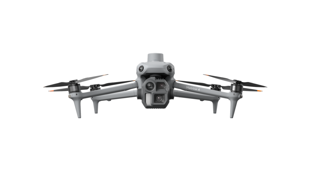
DJI Matrice 4E — Intelligent Geospatial Flight
Geospatial teams need aerial data that is fast to capture, accurate enough to build on and simple to share with the field — without hauling a heavy aircraft to every site. The DJI Matrice 4E meets that need in one compact, portable airframe, combining triple-camera imaging, integrated RTK positioning and an onboard laser range finder with DJI O4 Enterprise transmission. Part of the DJI Matrice 4 Series, it is engineered for professional survey, construction and mining teams that depend on reliable, repeatable results on every single flight.
See the Matrice 4 Series in Action
Triple-Camera Imaging System
Three cameras in one airframe — a 4/3 CMOS 20MP wide-angle mapping camera with mechanical shutter, plus 48MP medium-tele and tele cameras. Capture survey-grade orthophotos and inspect fine detail from hundreds of metres away, all in a single flight.
Laser Range Finder — Precise Measurement
An onboard laser range finder measures up to 1,800 m. Pin a point, draw a line or calculate an area in real time — then share it instantly with the team via DJI Pilot 2 or FlightHub 2.
O4 Enterprise Transmission — Up to 25 km
The O4 Enterprise system delivers a stable signal up to 25 km with a 20 MB/s downlink — fast route uploads and crisp live imagery, even in challenging or built-up environments.
Omnidirectional Obstacle Sensing
Six low-light fisheye vision sensors provide all-round obstacle sensing — automatic avoidance, intelligent rerouting and safe return-to-home, even in dark urban environments.
High-Efficiency Precision Mapping
5-directional oblique and 3-directional ortho capture, 0.5-second interval shooting and Smart 3D Capture cover up to 2.8 km² in a single flight. Distortion Correction 2.0 and auto-generated survey reports keep results accurate and repeatable.
Application Scenarios
- Surveying & mapping
- Construction monitoring
- Mining & volumetrics
- Geographic information systems
- Infrastructure inspection
Compatible Software
DJI Pilot 2 (flight control), DJI FlightHub 2 (fleet operations), DJI Terra (mapping & photogrammetry) and DJI Modify (3D model editing).
Key Specifications
| Wide-angle camera | 4/3 CMOS, 20MP, mechanical shutter |
| Medium tele camera | 1/1.3-inch CMOS, 48MP |
| Tele camera | 1/1.5-inch CMOS, 48MP |
| Laser range finder | Up to 1,800 m |
| RTK | Integrated, L5-band |
| Obstacle sensing | 6-directional low-light fisheye |
| Video transmission | DJI O4 Enterprise, up to 25 km |
| Max mapping speed | 21 m/s |
| Thermal camera | Not included (available on the Matrice 4T) |
| Flight time, weight & dimensions | See full datasheet |
Full specification datasheet and user manual: download link to be added.
Service & Warranty
Supplied with the standard manufacturer warranty. DJI Care Enterprise Plus is available for extended cover, free repairs and flyaway protection — backed by GulfNet Emirates after-sales support in the UAE. Browse more enterprise drones and payloads at GulfNet Emirates Shop.
FAQ
What is the difference between the Matrice 4E and 4T?
The 4E is built for geospatial work — surveying and mapping — with visible-light cameras. The 4T adds an infrared thermal camera and NIR light for inspection, public safety and emergency response.
Does it include RTK?
Yes — an RTK module is integrated for centimetre-level positioning.
Which software does it work with?
DJI Pilot 2, FlightHub 2, DJI Terra and DJI Modify.
Is a warranty included?
Yes — the standard manufacturer warranty. DJI Care Enterprise Plus is available for extended protection.
Reviews
There are no reviews yet.